Tradeoff Analyses in SeaSketch
A central element to GeoDesign is the ability to sketch any prospective design and freely explore any potential management solution. How can we achieve this while providing information that leads to optimal solutions? If you're a scientist, you're probably inclined to use modeling techniques to discover optimal solutions to problems your working on. Computer programs, for example, can be written to help you create spatial plans that maximize conservation value (e.g., habitat protection) while minimizing impacts to other planning objectives (e.g., wind energy potential).
If one is asked to design a marine spatial management plan that meets two objectives, say conservation and energy extraction, free-form sketching in applications like MarineMap and SeaSketch, is unlikely to generate optimal solutions. Furthermore, without assistance from computer models, it is a ton of work to narrow down the solution set. In the Marine Life Protection Act Initiative, stakeholder designs for Marine Protected Areas numbered in the tens of thousands. Facilitators then worked with stakeholders to narrow the number of potential solutions and get closer to consensus.
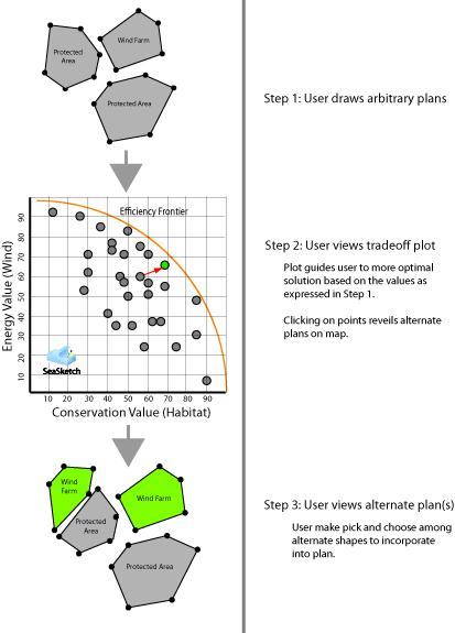
In collaboration with Dr. Crow White at UCSB, we are working on a solution to generating spatial plans that lies somewhere between a purely prescriptive model and a unrestricted GeoDesign-type application. In SeaSketch, users will still be encouraged to draw any arbitrary plan and learn about the potential consequences (e.g., conservation and energy value) of those plans. However, once those plans have been sketched, the user will also be presented with a tradeoff plot that shows where user-generated plans fall out relative to other potential solutions, including those that are closer to the "efficiency frontier."

More optimal plans, or those that do a better job of achieving the same objectives (as "stated" when a user sketches a plan) can be viewed, copied and incorporated into the original plan or they may simply be rejected.
It will always be important to allow users to accept or reject plans that are generated by computer models. The models may be scientifically robust but to feel ownership of the spatial plan, stakeholders must have the ability to sketch freely and compare those plans to those generated by other means - by other stakeholders or computer models alike.


