Using SeaSketch for Your Project
Technical & Project Support
Training (in-person or webinar)
Custom Feature Development
Overview of Services
Our team can customize SeaSketch to meet your project's goals, and initial setup can often be done the day you contact us. Scoping a project involves determining what level of technical support, training and custom development is needed. We charge a standard $1,000.00 license fee and an hourly rate for services. There is no additional overhead cost. Contact our team to discuss your specific project needs, and what level of support will fit best. Feel free to request a free demonstration project!
Services
With a wealth of combined experience in project management, marine planning and facilitation, software development, and GIS, our team ready to help ensure your project is a success. The following services are available as part of our standard hourly rate.
- Our lab can provide technical support to get you started on the right foot. Depending on the scope of your project, this may consist of basic support over the phone, comprehensive data management, or help integrating SeaSketch into your existing infrastructure.
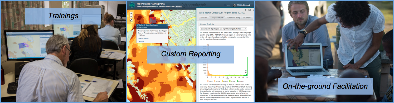
- We offer trainings to ensure SeaSketch fits into your project plan and users can make the most of what SeaSketch has to offer. We can provide online webinars, in-person range workshops, and on-the-ground project and process support.
- Custom Reporting Tools can be designed to match management goals to the best available science. User plans can be evaluated during the design phase in real-time, encouraging rapid iteration. Custom reports can be the key to connecting planners with relevant science and information.
- New Features can be added to SeaSketch as part of our bi-weekly release cycle. Features are made available to all projects in the system automatically as they are developed.
Typical Project Cost
| Baseline | Group Projects | Large Participatory Projects | |
|---|---|---|---|
| $3,000 | $15,000 - $20,000 | $30,000 - $80,000 | |
| Great for simple data sharing and use of existing features | Small to medium size groups requiring some advanced features | Large-scale marine planning with significant stakeholder involvement cost usually lower after first year | |
| Technical Support | 4 hours | 8 hours | 20 hours |
| Training | Webinar training 4 hours | In-Person Trainings 20 hours | |
| Custom Reporting | Simple Reports 40-80 hours | Sophisticated Reports 80-160 hours | |
| Project Support | On the Ground Facilitation 40-80 hours | ||
| Custom Development | Small to Large New Features 20-160 hours |
Contact our team to discuss your project and get a quote.
SeaSketch compared to other options
There are many options when it comes to web-based tools for viewing spatial data, and a few for engaging in spatial decision support and geodesign. You have the option to contract or develop internally a custom application to support your planning process. SeaSketch provides a unique value proposition compared to these other options. It is designed first and foremost as a collaborative spatial design and survey tool, and has many more features than tools designed for more general use cases. These unique features include accessible digitizing and analysis tools, map-based discussion forums to encourage collaboration, and a deep set of tools for interoperating with existing data sources. No other tool comes close to offering as many features in such a flexible package for collaborative geodesign.
Additionally, SeaSketch projects can be launched within hours or days. Other solutions - because they must be installed, configured and customized on a server for each deployment - take weeks or months to launch. This may delay your planning process or, at the very least, prolong your development period and increase associated costs.
SeaSketch is often compared to other options, so we'd like to provide our perspective on each alternative.
Desktop GIS
Desktop solutions are best reserved for single-user, computationally intensive
tasks. As soon as you want to engage more than one person in a collaborative
mapping exercise - particularly when you want to involve people who are not GIS
professionals - desktop GIS applications are severely limiting. Desktop GIS
packages such as ArcGIS for Desktop and QGIS are best view as powerful tools
to be handled by experts.
Custom tool development
Developing software is hard and uncertain... we know the pain. While it may seem easy to code up a data viewer using online templates and examples, as a your project progresses advanced features become a necessity. Not only must an application be built, but also maintained over time through staffing changes, updated to account for changes in browser technology, and hosted using reliable infrastructure. The fact is developing software is still more art than science. Most projects go over time and budget, and fail to meet initial goals.
SeaSketch is a mature and proven platform available today, hosted and maintained by dedicated and professional team. We have nearly a decade of experience supporting applications specifically for marine spatial planning.
ArcGIS Online
ArcGIS Online can be a valuable part of your data management system to complement ArcGIS Server. It provides tools for basic data viewing and analysis, and can help people find your data. That said, ArcGIS Online is a tool built for a general use case, with few affordances for collaborative geodesign. While "templates" can be used to augment the system's capabilities, these must be customized using Javascript which makes such a project another custom tool development job. The SeaSketch team evaluated ArcGIS Online as a basic platform to build upon initially, but found that it would not be possible to build SeaSketch within the constraints of ArcGIS Online.
Open-Source software
Open Source software typically comes in the form of small and highly useful libraries upon which developers can build larger applications. SeaSketch in fact is built on many open source libraries. There are no open-source planning tools available to facilitate a collaborative geodesign process "out of the box". The closest tool, MarineMap, was built by the McClintock Lab before we began work on SeaSketch. MarineMap must be customized by expert python and javascript developers, and hosted on reliable infrastructure that you setup. SeaSketch was built to replace MarineMap, and provide a much lower total cost to customize and deploy when compared to MarineMap.
Additional Resources
- To contact our team, email support@seasketch.org with a little information about your project.
- Download Brochure
- Answer our Intake Survey
Data Hosting Services
For many projects, data are not already housed on web servers. We create new server instances for you to publish data as map and analytical services. The cost of data hosting for your project depends on how much data you need to host, and how much traffic you expect on your SeaSketch project. We use Amazon Web Services.
- Hosting fees are typically $2,500- $10,000 per year
University License Fees
We offer a few types of license agreements, depending on your use of SeaSketch. All license fees are paid to the University of California Regents, and are separate from the Services Agreement for whatever additional services your project will require.
- Standard License - $1,000 / year / project
- Enterprise License - $10,000 / year / organization for unlimited projects
- Educational License - Free
Our Hourly Rate
Contact our team to discuss your project and get a quote.
No university overhead is a part of the McClintock Lab hourly recharge rate.
Our recharge rate is calculated specifically to support the lab itself, mostly salaries, with some other annual expenses. It takes into account "unproductive" (aka, non-billable) time that we require to continue introducing SeaSketch to new users, attend conferences, and conduct basic technical maintenance. We are a non-profit institution and therefore rates only cover our expenses.