Finding Common Ground
When creating plans, for the ocean or otherwise, it's often helpful to know if others are planning something for the same place. Knowing what others are planning can help reduce conflict and maximize the sustainable use of resources. With a recent SeaSketch update, this kind of work just got easier. The purpose of this adjacency tool is to help people understand who else wants data in the same area of interest, and to help facilitate the conversations that can then happen around partnering or leveraging each other’s efforts. Read about the project and SeaSketch features below.
Federal Mapping Coordination
The Integrated Working Group on Ocean and Coastal Mapping (IWG-OCM) and the 3D Elevation Program (3DEP) are using SeaSketch (fedmap.seasketch.org) to coordinate on mapping requirements and plans of Federal and state agencies around the country. These data are needed for a variety of reasons -- beach re-nourishment, engineering and repair decisions, habitat change assessments, stock assessments, nautical chart updates, marine debris detection and removal, inundation modeling, infrastructure strengthening for future storms and coastal resilience. The list goes on, but the common thread is the need for mapping data to support decision-making.
The goal is to help federal agencies and our partners collaborate on mapping data requirements and acquisition, for more opportunities to "map once, use many times." They hope to enable coordinated planning between agencies and with partners in order to meet more than one mapping need with the same data. And, they hope to convey where mapping is planned to happen in order to eliminate redundant efforts and acquire more data that everyone can use.
The kinds of activities mapped in SeaSketch include:
- Mapping data needs/requirements and priority areas for mapping
- Preliminary plans to acquire mapping data.
Mapping types include but are not limited to:
- Acoustic surveys (side scan/single/multibeam)
- Topographic, bathymetric, and topobathy lidar
- Digital imagery
- Hyper-spectral imagery
The emphasis is on preliminary plans. Many things - funding, schedules, priorities - can change before a mapping project is actually started. But the hope is that by using SeaSketch to enable early conversations on plans for mapping extents, standards/specs, sensors, resources available and so on, we can foster collaborations and efficiencies across the U.S. mapping community.
Discovering Overlapping Plans
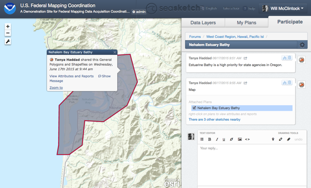
So, how does SeaSketch help users discover overlapping plans? In this case, users sketch polygons to indicate priority areas for mapping, then share those areas in a discussion forum.

TANYA HADDAD, WITH THE OREGON COASTAL MANAGEMENT PROGRAM, HAS SHARED A POLYGON IN A DISCUSSION FORUM. NOTE THAT HER MESSAGE INCLUDES A LINK THAT SAYS, "THERE ARE 3 OTHER SKETCHES NEARBY."
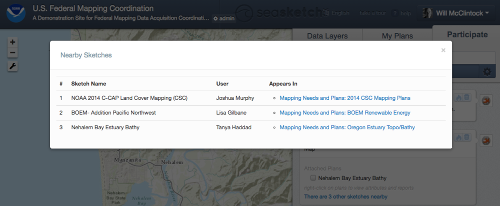
Once the polygon has been attached to a message in a forum, SeaSketch performs a geospatial analysis to determine whether there are adjacent sketches that have been shared. Clicking on the link brings up a list of adjacent sketches.

A LIST OF SKETCHES NEARBY TO THE ONE TANYA SHARED ABOVE. IT LOOKS LIKE LISA GILBANE, BUREAU OF OCEAN ENERGY MANAGEMENT, HAS POSTED A SKETCH TO THE FORUM THREAD ENTITLED "BOEM RENEWABLE ENERGY".
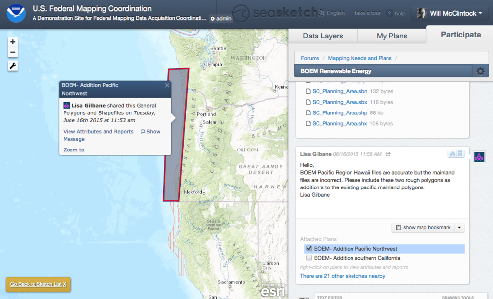
By clicking on the link to an adjacent sketch, several things happen:
- The map zooms to the location of the adjacent sketch.
- The adjacent sketch is turned on.
- The message to which the adjacent sketch was attached is turned on.

BY CLICKING ON THE LINK TO AN ADJACENT SKETCH, TANYA IS ABLE TO SEE THAT LISA POSTED A SKETCH TO A DIFFERENT THREAD ON THE PREVIOUS DAY.
Users can always return to the list of adjacent sketches by clicking on the link highlighted in yellow in the bottom left corner of the screen entitled, "Go Back to Sketch List."
In some cases, project administrators may wish to de-activate the adjacency reporting feature. Or, they may wish to adjust the adjacency tolerance, which defines how far away another sketch must be before it's not considered "nearby" anymore. Both of these actions may be taken by those with access to the Admin Dashboard.

THE PROJECT ADMINISTRATOR HAS ACTIVATED THE ADJACENCY AND REPORTING FEATURE AND SET THE TOLERANCE TO 1,000 FEET.
Post co-authored by Ashley Chappell and Will McClintock. For more information about this project, please contact Ashley Chappell (ashley.chappell@noaa.gov), NOAA Integrated Ocean and Coastal Mapping Coordinator.


